Delivering major workflow innovations for both typical surveying and specialized
applications, you now have the power to redefine your performance potential.
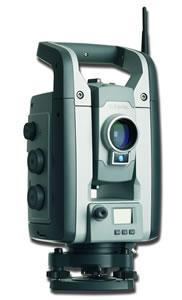
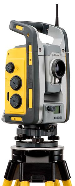
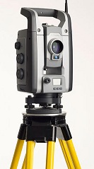
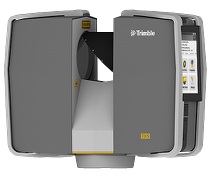
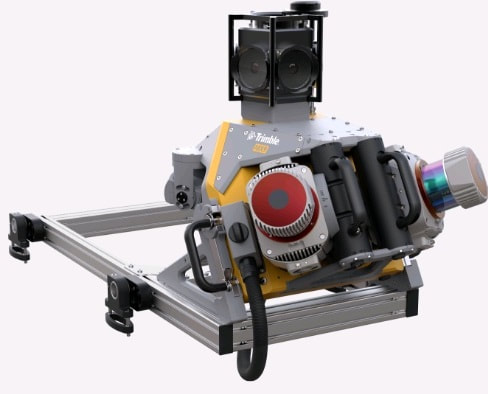
The Most Advanced Total Station Platform
The most demanding jobs require the most advanced total station in the industry. Whether you need solutions to drive productivity for day to day survey tasks or precision solutions for demanding engineering projects, the Trimble S8 is the most advanced total station solution available today. You can do more and do it better with the most innovative and advanced total station available today.
The new Trimble S8 Total Station provides a broad base of standard inclusions and configuration options for unmatched flexibility*:
Video-Assisted Control
With Trimble VISION you can see everything the instrument sees, without a trip back to the instrument.
Select targets with just a tap of the controller screen
Measurements are drawn to the video image, so you can be certain to never miss a shot you need.
Video-Assisted Documentation
Leave the site with more than just coordinates. With the Trimble S8, live images are captured with point-and-click efficiency.
Document important visual information like site conditions and details
Easily recall what was at the scene
Long-Range Accuracy
With the exceptional EDM1 range of Trimble DR Plus inside, you can extend your reach on the job for fewer setups and more measurements.
Precision Built
Angular accuracies of up to .5, combined with the Trimble DR High Precision EDM, provides the flexibility to tackle the most demanding projects.
Trimble FineLock technology allows the instrument to detect targets without interference from surrounding prisms for precision-build applications
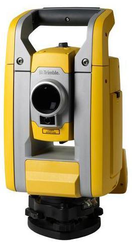
The new Trimble S6 DR Plus Total Station offers advanced MagDrive technology for breathtaking speed. It takes the work out of conventional servo or robotic surveying.
With an array of performance-enhancing features at your fingertips, the Trimble S6 is built for speed. And for surveyors on the move, the scalable system is fully upgradeable from Servo to Autolock and Robotic technologies.
MagDrive Servo Technology
With smooth, silent MagDrive servo motors, the Trimble S6 delivers exceptional speed and accuracy. Eliminating the wear associated with traditional drives, the instruments advanced error compensation provides fast, accurate measurement every time.
Capable of changing face at lightning speed and turning 115 per second, the Trimble S6 will keep pace with your every move.
Performance Features to Keep You Moving Fast
Trimble DR Plus effectively doubles reflectorless range, so hard-to-reach and unsafe targets are no obstacle to field performance
Trimble SurePoint The instrument automatically compensates for minor movements from wind, weather and sinkage
Intelligent tracking systems including Trimble GPS Search, MultiTrack Target and Target ID eliminate lost time due to lost targets
Combine GNSS and Optical techniques in the field.
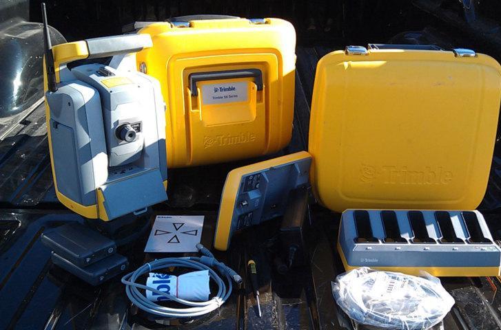
All you need to perform efficient surveying campaigns is included in the new Trimble S3 Total Station solution: An accurate and reliable instrument, integrated robotic radio and the popular Trimble TSC2 data collector (or fixed control unit for Servo and Autolock versions) with your choice of field software, integrated high capacity battery and dual charger, and prism.
The Trimble TSC2 controller, included in this solution, is one of the most trusted and reliable data controllers and works with your choice of Trimble field software: Trimble Access, Trimble Survey Controller, or Trimble Survey Manager.
Choose Servo and Autolock with integrated control unit, or full Robotic instrument with handheld Trimble TSC2 controller
Built on proven, reliable, Trimble technology
Dependability backed by world-class training, service, and support
Foundation for Integrated Surveying
Trimble Access on the Trimble M3 allows surveyors the optional availability of Trimble Access Roads module. Trimble Access Roads module imports road definitions from many third-party sources, allows users to key in a complete road definition including horizontal and vertical alignments, templates and superelevation, and widening records. Users are guided through fast offsets, slope staking, real-time redesign, and real-time quality control.
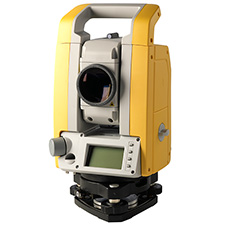
Lightweight, compact and rugged, the Trimble M3 Total Station provides powerful mechanical technology, backed by Trimble's world-class training, service and support network. Ergonomic controls, plus an integrated bright color touch screen display and keyboard, streamline and simplify the surveyor's work. World-class Nikon optics provide proven clarity, quality and precision for improved aiming and operation.
The tools to get the job done right
Take advantage of a complete total station solution. Reflectorless operation with Trimble DR technology can save time in the field by reducing instrument setups to reach desired measurement points. The high-accuracy EDM provides fast, reliable measurements to get the job done efficiently and away from hazardous situations.
With two-hot-swappable long-life batteries, the Trimble M3 will operate continuously for up to 26 hours. When power is running low, a quick battery change keeps you working without powering down.
Applications:
Layout of control
Checking or typing into property boundaries
Layout of excavation lines
Layout of concrete forms and anchor
As-built checks
Layout of control lines on concrete paid for subcontractor
Layout of hangers, sleeves and underground pipe
Light topographical measurements
Key Features:
Set up anywhere faster and perform all jobsite layout and measurement tasks yourself
One-person operation
Easy-to-follow user interface
Data storage and built-in checks for all layout functions
Rugged design
Maximum flexibility and cost
Reduced labor costs
Shortens learning curve and faster operation
Display clearly and eliminate errors
Withstands tough jobsite conditions and minimizes downtime due to repair.
you can focus on getting the job done.
Advanced Features
The easy-to-follow TS415 user interface results in a short learning curve and quick operation. With minimal training, you?ll find you don't need to be a surveyor to use the TS415. And because The TS415 has application programs solve most jobsite layout and measuring tasks, one user can perform all layout tasks normally outsourced to a third party, saving time and money. Simple-to-use software functions and advanced distance measurement technology help you finish the job faster and under budget.
Features
Bright, graphical user interface with easy-to-follow layout functions that follow a contractors workflow result in a short learning curve
Built-in checks on all layout functions and relevant data storage clearly display errors to reduce user mistakes
Battery lasts 27 hours on one battery charge increases productivity and reduces downtime due to power loss
IPX6 waterproof design withstands harsh jobsite conditions and minimizes repair costs
Compact transportation and storage allows everything to fit into one ergonomic carry case so nothing is lost, misplaced or damaged
Applications
Layout of control points on or offset to construction lines
Checking or tying in to property boundaries
Layout of excavation lines
Positioning of concrete forms/pinning footers
Anchor bolt layout
As-built checks
Layout of construction control lines on concrete pad for subcontractor use
Light topographical measurements for cut/fill balance
cadastral, building or construction
surveyor, the innovative Trimble
3600 Total Station series is designed
to optimize your workflow and field
productivity. You can easily upgrade
your 3600 series with tailor-made
software packages ranging from basic
to professional, and covering special
applications, thus further enhancing
the productivity of the system.
Increased Productivity
For operation in high productivity
environments, the QuickDrive,
Clamp Free Operation and Endless
Slow Motion deliver huge productivi-
ty gains over conventional tangent
screws. The ergonomically placed
Trigger Key close to the QuickDrive
screw activates the measurement
quickly and conveniently.
DR Measurement Mode
The innovative DR EDM system
option is ideal for surveying where
the target is difficult, impossible or
dangerous to reach. It opens up a
world of new applications — build-
ing elevation surveys, tunnel profil-
ing, measuring to objects on private
land, and safe positioning of points
in active traffic. This system enables
you to measure to any object within
80 m (262 ft) (standard Kodak Grey
18% reflective) and up to 150 m
(492 ft) (Kodak White 90% reflec-
tive), with no need for a prism. The
Coaxial Visible Spot facilitates aiming
in interior applications.
Data Capture
The 3600 series of instruments have
two choices of User Interface. One is
the programmable DOS Open
The productive Trimble 3600 Total Station series is ideal for all types of survey work.
System Architecture, with 4Mb
memory, Custom Applications, possi-
bility to run both 3rd Party Software,
e.g. TDS, and the Zeiss Elta Soft-
ware. Another choice is the detachable Geodimeter
Control Unit with
color-coded keys, containing a wide
variety of software applications, and
up to 8.000 point memory capacity,
etc. The existing Geodimeter users
can thus move to the new platform
with no change to routine operation.
Wireless Communications
with the Office
The 3600 series utilizes industry stan-
dard infrared (IR) communications in
addition to conventional RS-232
communications. Using the IR com-
munication port you can transfer files
to and from certain cellular phones
without the need for a cable. The cel-
lular phone can transfer your data to
or from the office without the need
for you to ever leave site — ideal
when you arrive at the job site with-
out all your data!
Integrated Surveying
The 3600 series is the ideal comple-
ment to the Trimble GPS Total
Station5700, providing a means of
filling in detail that cannot be
acquired using GPS. The two are
seamlessly linked using the Trimble
Control Unit, enabling you to easily
switch between RTK and total station
measurement. All the combined data
can be processed and analyzed within
the Trimble Geomatics Office
software.
Providing all the benefits of a con-
ventional total station, with optional
DR capability, the Trimble 3600
Total Station series can make you
more productive than ever before.
2" and 5" angle accuracies
Prism and DR measurements
Fast, accurate EDM provides fast, reliable measurements
Long life Li-ion Battery
Easy-to-use keypad
Rugged and lightweight system design
Dependability for your Survey Crews
Trimble dependability at an affordable price
Rugged, lightweight and feature packed for long days in the field
Proven Range, Accuracy and Quality
Available in 2" and 5" single face midels
Provides 3000m range to a single prism
Up to 400m DR range to non-reflective surfaces
Simple Intuitive Onboard Software
Easy to use dual or single face keypads to operate the instrument
Intuitive, quick to learn and field proven interface and onboard data collection software
Two user-programmable measure keys for separately configuring measurement parameters
Bluetooth Connectivity to External Controller
Integrated wireless Bluetooth connection
Gives you the power of Trimble Access field software on an external controller
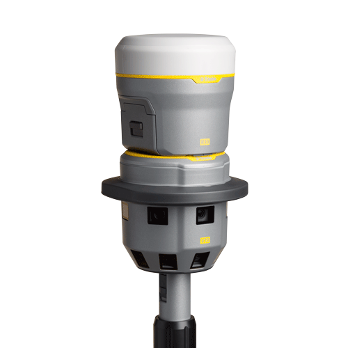
Generate Survey, GIS or mapping accuracy positions from images
Rapid data collection with one-button capture of panoramas
12 calibrated cameras capture 60 MP panorama for full site visualization
High Dynamic Range (HDR) imagery improves image quality
Seamless integration with the Trimble R-series GNSS receivers, Trimble VISION total stations or use standalone
Familiar, easy-to-use workflows in Trimble Access field software
Flexible, simple processing in Trimble Business Center to generate deliverable.
Features
Generate Survey, GIS or mapping accuracy positions from images
Rapid data collection with one-button capture of panoramas
12 calibrated cameras capture 60 MP panorama for full site visualization
High Dynamic Range (HDR) imagery improves image quality
Seamless integration with the Trimble R-series GNSS receivers, Trimble VISION total stations or use standalone
Familiar, easy-to-use workflows in Trimble Access field software
Flexible, simple processing in Trimble Business Center to generate deliverable
Surveying, imaging and 3D scanning in one powerful solution - take one instrument to the job site to perform all of your data capture needs. No need to invest in or transport multiple instruments.
Increase your ability to adapt to any Situation - having the capabilities of a traditional survey instrument combined with scanning and powerful image capture all in one device you are prepared for even the most unique data capture situations.
Create enhanced 2D and 3D deliverables for rich information management - the comprehensive datasets captured with the Trimble VX allows users to deliver compelling results to clients which are easy to understand and help speed decision making. Produce enhanced deliverables such as 3D as-builts, textured models, inspection maps, volume/surface calculations and more.
Capture and combine scanning, imaging and surveying deliverables with the singular solution designed for surveyors. Integrating the technologies of advanced optical surveying, metric imaging and 3D scanning, the Trimble® VX™ Spatial Station is the only surveying instrument that does it all and does it with ease.
To improve the efficiency of capturing advanced Spatial Imaging deliverables, Trimble provides an integrated solution for bringing these technologies together within the traditional workflows surveyors already use. So you have the flexibility to perform feature-rich scans every day, without the complexity of setting up a separate scanning system or switching to specialized field software.
Video-Assisted Control
Trimble VISION™ gives you the power to see everything the instrument sees. Direct your work with live video images on the controller Now you are free to capture measurements to prism or reflectorless surface with a point and click.
Empower Your Surveys with Trimble RealWorks
With the ability to capture metric images with the Trimble VX in the field, you are also able to make additional measurements and attribute the data back in the office. Advanced 3D models and image-rendered 3D surfaces are within your reach with the rich data delivered by Trimble Spatial Imaging sensors and the powerful workflows of Trimble RealWorks™ software.
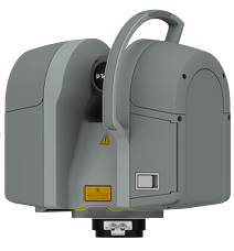
High speed- with a typical scan time of only 3 minutes the Trimble TX8 allows you to capture more stations and complete projects faster than ever.
High quality data- never compromise on data quality. The Trimble TX8 quickly captures only high quality data over its entire range even in direct sunlight. This means less setups to capture a complete project.
Long range- with a maximum range of 340 meters the Trimble TX8 gives you more flexibility and project opportunities. It’s like having two scanners in one.
Intuitive and easy to operate- the intuitive onboard software of the Trimble TX8 makes it easy to learn and get up to speed capturing data. Reduce startup time and increase your confidence that 3D scanning can be successfully incorporated.
The Trimble TX8 delivers the power and flexibility to tackle even the most demanding projects. Designed for performance the Trimble TX8 enables you to complete 3D laser scanning projects faster than ever.
1 million points per second
Typical high quality scan time of only 3 minutes
IEC EN60825-1 class 1 eye safe laser
High accuracy maintained over entire range
340 meter range
With the Trimble TX8 you can capture more detailed datasets at high speed while maintaining high accuracy over the entire range of the scan.
Versatile and cost-effective solution
Compact, lightweight, and portable
Integrated color camera for creating photorealistic scenes
Intuitive touch screen interface ideal for new users
WLAN remote control
Trimble RealWorks included for processing and deliverable creation
High-speed scanning with powerful 3D deliverables
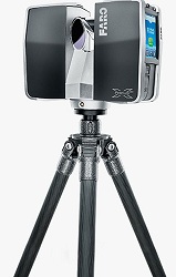
The FARO Focus3D X 130 laser scanner is a highly versatile 3D scanning solution for a broad variety of applications like complex plant environments, buildings and infrastructure, architectural and heritage sites, accident and forensic scenes, and more. The compact, lightweight design, and intuitive, easy to use onboard interface increases field efficiency, saving you time and money. Included with the system, Trimble® RealWorks® office software transforms your data into powerful 3D deliverables.
Compact Lightweight- smallest and lightest scanner available providing you enhanced mobility that increases productivity around the job site and reduces setup time.
Efficient- reduce time to generate customer deliverables by rapidly capturing high resolution, accurate data. Additional color capture provides close to real world visualization of the scene.
Economical- capture high resolution data economically without a large upfront investment. Perfect for entry into 3D laser scanning and versatility for many applications allows you to quickly realize your ROI.
Ease of Use- the Trimble TX5 clear and concise touch screen interface and intuitive onboard software makes it easy to learn and get up to speed capturing data. Reduce startup time and increase your confidence that allows 3D scanning to be successfully incorporated.
The Trimble® TX5 3D laser scanner is a revolutionary and highly versatile 3D scanning solution for a broad variety of scanning applications. The compact and lightweight design provides unmatched mobility at the job site, increasing field productivity. The intuitive and easy to use onboard interface allows new users to quickly get up to speed.
Versatile and cost-effective
Compact and portable
Integrated color camera for creating photorealistic scenes
Intuitive touch screen interface ideal for new users
Trimble Juno 5D Enhanced GPS Barcode Handheld (WEHH)
Enhanced GPS handhelds require SBAS corrections (WAAS or EGNOS).
Key Features:
Familiar, easy-to-use, smartphone form factor
Works with professional software and built for GIS workflows
Big, sunlight readable screen so can really work with data
Rugged for work in all conditions
Truly a phone to stay in touch with the office, powerful modem for connected solutions
1D/2D barcode reader
uno 5D barcode handheld (WEHH)System
Integrated 3.75G cellular data, text, and voice capability (Juno 5D only)
8 megapixel camera with geotagging and dual LED flash
Bluetooth® v2.1 with enhanced data rate
Wi-Fi (802.11b/g/n)
Multi-touch 4.3 inch WVGA sunlight-readable Gorilla® glass display
Long-life, rechargeable Li-Ion battery
1 GHz, Texas Instruments DM3730 processor
512 MB RAM
16 GB Flash storage
MicroSD memory card slot (supports SDHC up to 32 GB)
Integrated speaker and microphone
Windows Embedded Handheld 6.5
1D/2D Barcode Reader
Standard Software
Windows Embedded Handheld
Microsoft® Office Mobile® 2010 (Excel Mobile, Word Mobile, Outlook Mobile,
PowerPoint Mobile, and Internet Explorer Mobile 6)
Trimble SatViewer (GPS interface application)
Trimble CellStart (WWAN configuration application)
Microsoft My Phone with SMS text messaging (Juno 5D only)
Camera control application
Calculator and calendar
Microsoft pictures & videos
Windows Media Player
Windows Live Messenger
Microsoft Task Manager & Notes
Adobe Reader LE 2.5
Standard Accessories
International AC charging kit
Wrist strap
USB cable
Quick Start Guide
Ultra clear screen protectors (2-pack) kit
System
8 megapixel camera with geotagging and dual LED flash
Bluetooth® v2.1 with enhanced data rate
Wi-Fi (802.11b/g/n)
Multi-touch 4.3 inch WVGA sunlight-readable Gorilla® glass display
Long-life, rechargeable Li-Ion battery
800 MHz Texas Instruments DM3730 processor
256 MB RAM
8 GB Flash storage
MicroSD memory card slot (supports SDHC up to 32 GB)
Integrated speaker and microphone
Windows Embedded Handheld 6.5
1D/2D Barcode Reader
GPS
High-sensitivity GPS/SBAS1 receiver and antenna
Standard Software
Windows Embedded Handheld
Microsoft® Office Mobile® 2010 (Excel Mobile, Word Mobile, Outlook Mobile,
PowerPoint Mobile, and Internet Explorer Mobile 6)
Trimble SatViewer (GPS interface application)
Trimble CellStart (WWAN configuration application)
Camera control application
Flashlight mode control application
Calculator and calendar
Microsoft pictures & videos
Windows Media Player
Windows Live Messenger
Microsoft Task Manager & Notes
Adobe Reader LE 2.5
Standard Accessories
International AC charging kit
Wrist strap
USB cable
Quick Start Guide
Ultra clear screen protectors (2-pack) kit
Juno 5D Handheld (WEHH) - Trimble announces the next generation of the Juno® family, the Trimble® Juno® 5 series—a smartphone-inspired handheld that combines must-have functionality with the familiarity of a smartphone form-factor.
Bringing GIS out to the field
Customers can stay flexible and connected with the optional built-in communications to send and receive calls and data on the job—keeping teams productive, informed, and in touch.
Perfect for asset management and data maintenance projects, everything is integrated into a convenient, rugged package: high-sensitivity GNSS, Windows® Embedded Handheld (WEHH) operating system, Microsoft® Office applications, camera, and cellular connectivity onboard.
A smarter approach to field productivity.
It may look like a smartphone, but the Juno 5 series is all business. Rugged enough to meet military specs, with an IP65 rating, it has a large screen to easily view data or photos even in direct sunlight. Teams can be confident they have a real, professional tool—built to work in even the toughest conditions.
Professional workflows.
Together with Trimble TerraSync™ and GPS Pathfinder® Office software for professional workflows, users can work with confidence in the data they are capturing.
Trimble Juno 5D Enhanced GPS Barcode Handheld (WEHH)
Enhanced GPS handhelds require SBAS corrections (WAAS or EGNOS).
Key Features:
Familiar, easy-to-use, smartphone form factor
Works with professional software and built for GIS workflows
Big, sunlight readable screen so can really work with data
Rugged for work in all conditions
Truly a phone to stay in touch with the office, powerful modem for connected solutions
1D/2D barcode reader
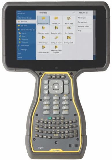
Large 7-inch multi-touch display
Ergonomic design with backlit keyboard
Trimble Access 2018 compatible and Windows 10 Pro
Multi-tasking power and convenience
hot-swappable rechargeable batteries
RUGGED
The Trimble TSC7 is water and dust resistant to withstand the toughest weather and
jobsite conditions.
Military-spec, IP68, rugged design, engineering and performance
Designed for operation in all light conditions
Operates in temperatures ranging from -30 °C to +60 °C (-22 °F to 140 °F).
FLEXIBLE
The TSC7 Controller is designed to operate with Trimble Site Positioning Systems
hardware, including the SPS986 GNSS Smart Antenna, SPS855 GNSS Modular
Receiver, and SPS series total stations. Integrated Bluetooth® wireless technology
delivers cable-free communication between the TSC7 and Trimble GNSS Receivers.
The removable 2.4GHz Radio Empower® module can be easily moved between TSC7
controllers.
APPLICATIONS
Whether you’re using a total station or GNSS, the TSC7 controller
gives you total control over on-site tasks. It is especially useful for:
Construction surveyors
Grade checkers verifying grade and checking as-builts with a GNSS rover
Utility locators
TECHNICAL INFORMATION
Features and specifications include:
Optimized for Trimble Siteworks Software
Large 7-inch multi-touch screen for finger, gloves or stylus
Sunlight readable display
Secure Windows® 10 Pro operating system
Intel Pentium processor with 8 GB RAM and 64 GB internal memory
Comprehensive connectivity options
Front- and rear-facing cameras
Backlit keypad with customizable button commands
Ergonomic form factor
Hot-swappable batteries with LED indicators
Streamline the flow of everyday survey work and make field work more efficient with the fully integrated TSC3 controller
Windows
Operating System
10.7 cm / 4.2"
Screen Size
Purpose-Built Design
Large, bright high resolution screen
Choose from a QWERTY or conventional alpha-number keyboard
Automatically geo-tag captured images
Navigate and find control points and other assets quickly with integrated GPS
Receive direction cues with the internal compass
Bluetooth wireless technology eliminates cables
Real-Time Communications
Wireless internet connectivity with integrated GSM/GPRS modem
Trimble AccessSync enables real-time synchronization between field and office
Download and upload files anytime, anywhere
Connect with VRS connections using the internal modem
Fully-integrated camera
Features of the Trimble TSC3 Include:
Microsoft Windows Mobile 6.5
Full alpha and numeric keypad
Touch Screen
Battery Life up to 30 hours and complete recharge in 4.5 hours
integrated speaker and microphone
rugged polycarbonate shell
MIL-STD-810F specs for dust and water
Bluetooth
And More
Standard Accessories for the Trimble TSC3 Include:
AC Charger
Standard CF-Cap
Screen Protectors
Rechargeable Li-Ion PowerBoot
USB Data Cable
User's Guide
Hand Strap
Stylus
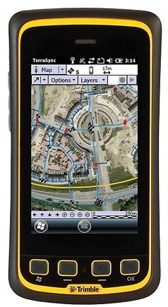
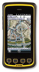
5 MP autofocus camera and LED flash
Take digital photographs of your job site right from the control
Record qualitative information, such as site conditions or work progress
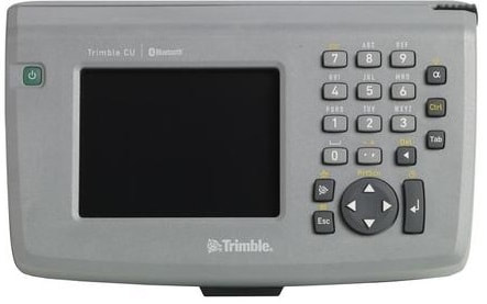
Windows Embedded CE 6.0 R3
Operating System
8.9 cm / 3.5"
Screen Size
A Windows CE .NET device
Windows® Embedded CE 6.0 R3 operating system.
Designed to support the latest Trimble survey systems including the Trimble R10 GNSS system and the Trimble S7 and S9 total stations.
Runs your choice of powerful Trimble field software such as Trimble Access and Trimble Survey Controller, plus other specialized Windows software as needed.
View background maps and check work on the color graphic display for greater data control and confidence.
Integrated Bluetooth wireless technology
Eliminate the hassle of cables and expedite setup with integrated Bluetooth® wireless technology for speed, convenience and ease of use.
Trimble Access optimized
Trimble Access™ field software available on board the Trimble CU controller offers numerous features and capabilities to streamline the flow of everyday surveying work.
Collect GNSS and optical data in one job file by simply switching between sensors.
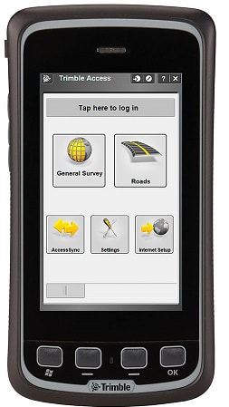
A compact mobile survey controller
WEHH 6.5
Operating System
10.9 cm / 4.3"
Screen Size
Survey data collection and voice in one device
Offers voice, SMS text, and 3.75G cellular data transfer capabilities
Transfer data to and from the cloud using Wi-Fi or WWAN connections
Connect to a Trimble VRS™ network via high speed connection capabilities
Connect directly to, and control, the Trimble R4 GNSS receiver using the controller's integrated Bluetooth® capability
Enhance documentation and point attribution by capturing geotagged, high quality, digital photos with the integrated 8 MP camera
Navigate directly to points using the internal GPS and Compass
Your mobile office in the field
Runs Windows Embedded Handheld 6.5 Professional Operating System and Microsoft Office Mobile 2010
Optimized for Trimble Access™ field software for survey workflow support
Run software applications quickly and easily
Transfer files to the office using integrated communications technology
Compact and rugged design
Slim, ergonomic, lightweight – weighs only 13.5 ounces
4.3 inch capacitive touch, Gorilla glass display provides superior sunlight readability without sacrificing durability
Withstands a pole drop of 1.22 m (4.0 ft) onto a concrete surface
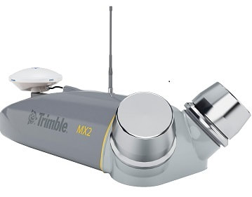
The Trimble MX2 is a vehicle-mounted spatial imaging system which combines high resolution laser scanning and precise positioning to collect geo-referenced point clouds for a wide range of requirements. The dual head system contains a combined Trimble Applanix GNSS and inertial geo-referencing module for precise positioning. It can be rapidly deployed onto on- and off-road vehicles of all sizes, and significantly reduces project field time and operator skill levels compared to traditional techniques. The MX2 is supplied with Trimble's proven Trident software to rapidly extract and analyze the raw data to turn it into useful geospatial intelligence.
Features
High performance laser scanner captures fully synchronized point clouds
Precision positioning using tightly coupled GNSS and inertial referencing system
Rugged, reliable and lightweight design with low power consumption
Deploys on all sizes of on- and off-road vehicles, quad bikes, and boats
Use with Trimble Trident software for data capture, extraction and analysis
Benefits
Versatile system offers significant operational flexibility
Outstanding performance and value with low cost of ownership
Optimizes staff utilization and lowers skill requirements
Reduces project timescales through fast deployment, data capture, and analysis
Highly efficient, proven analysis workflows
Enhances operational capabilities and expands market opportunities
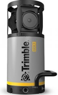
The Trimble MX7 Mobile Imaging System is a fast and cost effective way to manage assets such as bridges, buildings, roads, highways, and power stations, and document site conditions with geo-referenced images.
Rapid 360-degree geo-referenced image documentation
Precision positioning using GNSS and inertial referencing system
Deploys on all sizes of vehicles
Rugged, reliable and lightweight design with low power consumption
Applications
Local government: asset inventory and management, city models
Mining: construction, monitoring
Oil and Gas: site monitoring, asset tracking, change detection
Utilities: electrical, pipelines
Large scale mapping
Roads: condition surveys, visualization, maintenance
Software
The Trimble MX7 allows you to visually observe and capture the job site, then produce deliverables in the office later using Trimble Trident and Applanix POSPac™ MMS software. Trident Imaging Hub software is available with the system and offers robust object positioning, measurement, data layer creation, 3D models and analysis of geo-referenced imagery
Key Features
Very high point cloud density with complimentary immersive imagery
Advanced Trimble GNSS and Inertial technology
Lightest and most compact premium mobile mapping system
Simple installation and browser based operation from any smart device
Compatible with existing Trimble software and workflows
Enhanced remote support capabilities
Applications
Whatever the application, the Trimble MX9 quickly and efficiently collects the highly
precise and powerful data you need, and delivers it across your organization.
Whether you are a city planner, work for a department of transportation or are a service provider, count on it for generating deliverables such as:
Road assets
Cross sections
3D models
GIS layers
Elevation models
Volumetric analysis
